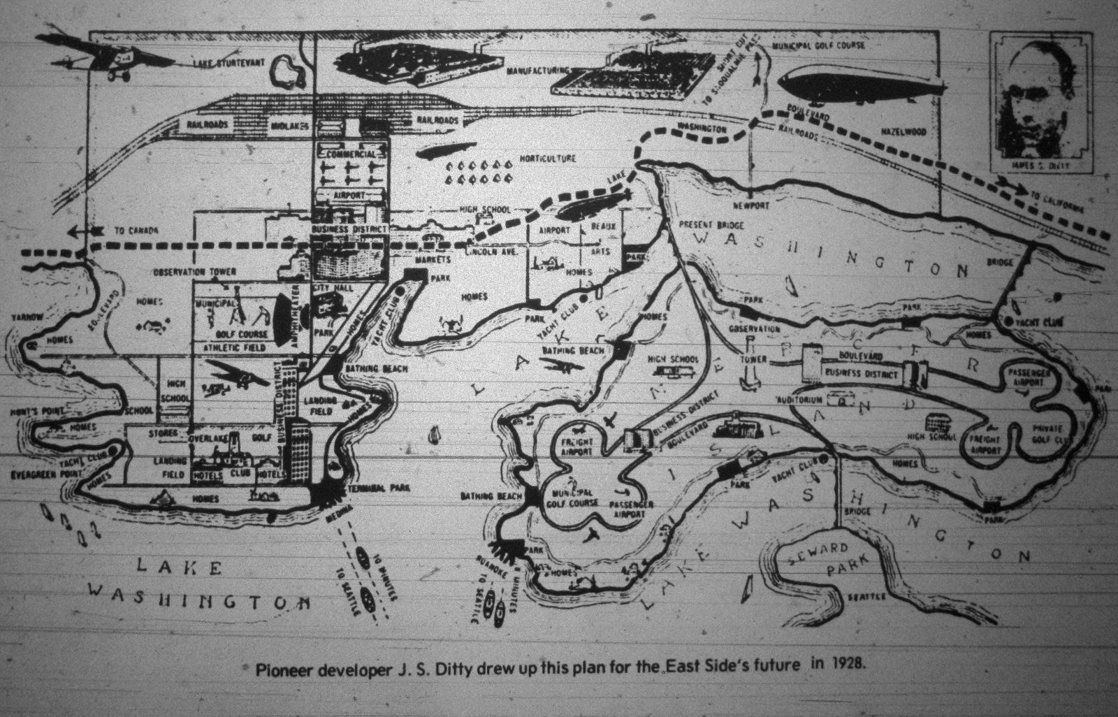
Bellevue American, April 15th 1972 (click for larger version)
Once again, I apologize for the shortage of posts here recently, I’ve been dealing with a minor crisis or two (specifically, finding myself looking for a job AGAIN, if anyone out there needs an SDET with C# skills and extensive test experience, feel free to let me know) and I’ve been a bit short on material lately. While I was doing some research on another post you should be seeing soon here, I came across a number of articles in 1972 editions of the Bellevue American regarding what was known as the “701” study, an inventory of some of the City of Bellevue’s characteristics and projections of its future. Included with an article that contained a number of facts, figures and projections. One of these predictions suggested that at its then current rate of growth, Bellevue would have a population of somewhere between 100,000 and 140,000 by 1990, a prediction which ultimately proved too high, as the 1990 census showed a population of 86,872 in the 1990 census, and as of 2008 was estimated to be somewhere around 119,000. The formatting of the article itself will require some messing around to get it into a postable form, so I’ll revisit that later. Perhaps more interesting than the article itself is this rather odd looking map, which was included with the article.
This map was devised by a developer by the name of James Ditty, and was intended to show how Bellevue and Mercer Island would look at some point in the future. Unfortunately, the relatively low quality of the images on the microfilm don’t provide for a whole lot of detail, but there’s still plenty to see. As tends to happen with most speculation on the future, much of what was predicted here turns out to have been spectacularly wrong. The first thing that stands out on this particular map is the airports. It seems that Mr. Ditty felt that Mercer Island alone would require no less than four airports, two on each side of the island. Bellevue was also given two airports of its own, plus two “landing fields” (presumably for the zeppelins that we were going to all be traveling on back before the Hindenburg developed its little exploding problem in 1937.) It’s also somewhat difficult to imagine Bellevue without its freeways, but this map doesn’t include any of them. In fact, the trip across the bridges across Mercer Island to Seattle seems to take some rather pointless detours around the airports and golf courses, because apparently nobody was ever going to need to get to work on time in this future world. There are also railroad tracks found in roughly the place where they still exist today, but this map seemed to suggest there would eventually be a lot more of them than Bellevue ended up with. This map did correctly predict the construction of a bridge from Mercer Island to Seattle, but puts it in the wrong spot (although this map puts the bridge in the shortest distance between the two.) It also adds a second bridge to Mercer Island from the east side of Lake Washington that never got built. The 520 bridge doesn’t exist here at all, since apparently you don’t need one if there isn’t any 520 in the first place.
On the other hand, there are also some things that this map ultimately got correct. The central business district of Bellevue is in roughly the correct location (although it has begun to grow out of this area in recent years. The few manufacturing operations in the Midlakes/Bel-Red neighborhoods that did develop in Bellevue were placed relatively close to their ultimate location on this map, and Meydenbauer Bay did eventually become the home to a yacht club and swim beach, as shown on this map. Even so, much of what was suggested here turns out to have been quite outlandish in retrospect, and bears little resemblance to the Bellevue that we know today. It’s always fun to speculate though, right?

Aperently for recreation we were all going to fly our planes to the golf course or go to the bathing beach, and what was the need for the “observation towers”?
Comment by JBL — January 13, 2010 @ 4:12 pm
Ha! This is my great, great, granfathers map. I had actually never seen this before. I’ll have to show my dad as I’m sure he hasn’t either and it is very interesting. Maybe he predicted the three generations of pilots in his family that would succeed him haha.
Comment by James S Ditty IV — February 19, 2010 @ 8:13 pm